
Stonex S580+
6,873.27 ₾
GNSS Receiver for GIS & RTK Applications
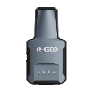
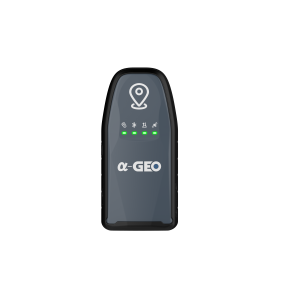
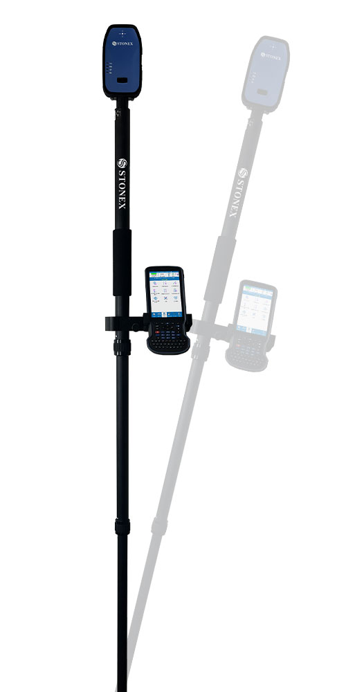
The S580+ is a compact and lightweight GNSS receiver with exceptional performance and centimeter precision, thanks to the GNSS board with 1408 channels. The S580+ works with GPS, GLONASS, BeiDou, Galileo, and QZSS satellite systems and it is equipped with IMU technology that supports inclined measurements. Compared to traditional GIS products, the S580+ is a high-precision, intelligent data acquisition receiver that can be worn or attached to a pole, offering greater freedom of movement and flexibility.
Additional information
| Brands | |
|---|---|
| Condition | |
| Seller | |
| Industries | Construction, Cadastre, Communication, Geodesy, GIS & Mapping, Maining, Monitoring, Oil & Gas, Remote Sensing |
Delivery Service
Megageohub delivers products purchased up to 500 (five hundred) GEL within the city of Tbilisi by the postal service selected by it for 10 GEL, within 2 working days of purchase, and in the region for 20 GEL, within 5 working days of purchase. Delivery of items above 500 (five hundred) GEL is free.
Item Ordering Conditions
You can order this item from us, send us your contact details and we will contact you within 48 hours.
Product delivery time is 15-30 days.
To order the product, send us your contact details
- Description
- Additional information
Description
GNSS Receiver for GIS & RTK Applications
The S580+ is a compact and lightweight GNSS receiver with exceptional performance and centimeter precision, thanks to the GNSS board with 1408 channels. The S580+ works with GPS, GLONASS, BeiDou, Galileo, and QZSS satellite systems and it is equipped with IMU technology that supports inclined measurements. Compared to traditional GIS products, the S580+ is a high-precision, intelligent data acquisition receiver that can be worn or attached to a pole, offering greater freedom of movement and flexibility.
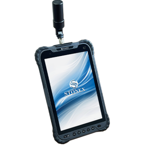
The S580+ can communicate with an external device such as a tablet, smartphone, or PC via Bluetooth and Wi-Fi. The receiver can be configured via the internal web interface or the Cube-connector app to receive RTK differential corrections and connect seamlessly to survey or GIS third-party software. The rubber protective cover increases device protection, is non-slip and non-damaging; the overall device protection reaches IP67 and withstands drops from 1.2 meters on hard surfaces.
IMUs are sensors that utilize a combination of accelerometers, gyroscopes, and magnetometers to accurately track movement and orientation. These advanced sensors offer a valuable solution for surveying in difficult or inaccessible locations where traditional methods may not be practical.
| Receiver | |
| Satellite signals tracked | GPS, GLONASS, GALILEO, BEIDOU, QZSS, IRNSS, SBAS |
| Channels | 1408 |
| Internal Memory | |
| TilT Sensor | IMU |
| Postioning | |
| Static Surveying | |
| Horizontal | – |
| Vertical | – |
| Real Time Kinematic | |
| Horizontal | 2 სმ. |
| Vertical | 2 სმ. |
| Laser survey | არა |
| System | |
| Processor | T113 |
| Operaiting System | Linux |
| Ram | – |
| Flash | – |
| FT Slot | – |
| Display | – |
| Display size | – |
| Resolution | – |
| Brightness | – |
| Camera | – |
| Rear/Front | – |
| Comunication | |
| Internal Modem | – |
| Bluetooth | V2.1 + EDR / V4.1 |
| Wi-Fi | 802.11 a/ b/g |
| Navigation outputs | NMEA 0183 |
| Power Supply | |
| Battery | შიდა დატენვის, 7.2 V – 7000 mAh |
| Working Time | 10 საათამდე |
| Physical Specification | |
| Dimensions | 130 მმ. x 64მმ.x 31მმ. |
| Weight | 0.315 კგ. |
| Operating Temperature | -30°C to 65°C |
| Waterproof/Dustproof | 67 |
Additional information
| Brands | |
|---|---|
| Condition | |
| Seller | |
| Industries | Construction, Cadastre, Communication, Geodesy, GIS & Mapping, Maining, Monitoring, Oil & Gas, Remote Sensing |